News
Celebration of International Women's Rights Day 2024 at Bureau Veritas Côte d'Ivoire
Pedological study & mapping
Soil fertility
map
Bureau Veritas’ laboratories helping to optimise agricultural efficiencies
Beyond analytical services, we interpret your testing results and we offer personalized advice to support you to choose the fertilization program that would be better to optimize your results.
BUREAU VERITAS PROVIDES YOU WITH SPECIALIZED AGRICULTURAL SERVICES

Discover : Field trial monitoring by Scanner
-
Soil Electro Conductivity
Measures soil texture variability deep into the profile.
-
Soil OM
Measures soil organic matter using optical sensors.
-
PH
pH measurement at 5 or 7 cm in the ground 1 measurement / acre
-
Topography
Based on GPS, scanners register topography, tanking into consideration altitudes, slopes and curves.
From measure to soil map
- The scanner is tracted and collects data.
- We have -at this stage- gradientmaps.
- With soil analyses, Sensor data is calibrated and smoothed. We can calibrate our different maps (CEC, OM, P&K….)
SUBJECTS TO EXPLORE
« Water Management » maps:
- Precision irrigation tools.
- Optimization of probes positioning
Plant protection products variable rates
- Herbicides related to OM
- CEPP action (French registration)
Pest risk maps:
- Any pest related to soil criterias (texture, OM, Topography)
- Ex: rhizoctonia on Sugarbeet
Nitrogen variable rate based on an algo which fuses OM, CEC and topography map
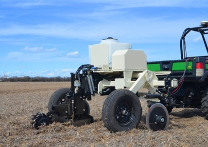
Field trial monitoring by Scanner
- Image
Agricultural laboratories